INDEPENDENT
Sceptics cast doubt on 15-year-old William Gadoury's discovery

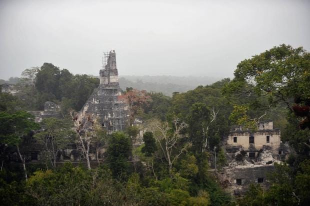
Using Google Earth and a home computer, a 15-year-old schoolboy discovered the remains of a long-lost Mayan City.
William Gadoury, from Quebec, Canada, compared maps of 22 star constellations known to the ancient Maya with Google Earth images of Mexico’s Yucatan peninsula.
He found the positioning of 117 known Mayan cities corresponded to the patterns of the constellations, with the biggest cities matching up with the brightest stars – a link no-one else had made before.
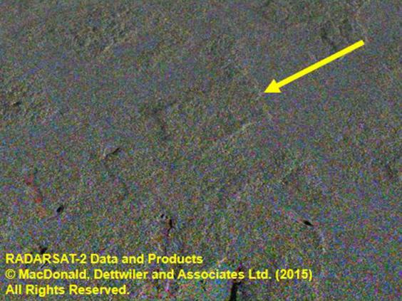
Then he went even further and investigated a little-known 23rd Mayan constellation. Lo and behold, using satellite images he found on the web and photographs sent to him by the Canadian space agency, William found what looked like the remains of a Mayan city, right where the constellation suggested it would be.
Experienced scientists spoke in wonderment of signs that the Mexican jungle might be hiding what had once been an 86-metre (282ft) high pyramid and about 30 buildings, making the city – named K'aak Chi (Mouth of Fire) by William – one of the five largest known Mayan conurbations.
A Canadian newspaper declared William “the little star of Nasa, the Canadian space agency and the Japanese space agency.” William spoke of being “really excited.”
There was just one problem. Some archaeologists and anthropologists have started saying it was all too good to be true.
That square seen in the satellite images, they said, the one where the giant pyramid is supposed to be: it’s probably just an old cornfield.
Perhaps the most outspoken of the critics was David Stuart, professor of Mesoamerican Art and Writing at the University of Texas at Austin.
In a tetchy post on his Facebook page, he wrote: “The current news story is false. I was trying to ignore it (and the media inquiries I’ve been getting) but now I feel I ought to say something.
“The whole thing is a mess – a terrible example of junk science hitting the internet in free-fall.
“The ancient Maya didn’t plot their ancient cities according to constellations. Seeing such patterns is a Rorschach process, [ie like the psychological test where people are asked to look at ink blots and say what they see], since sites are everywhere, and so are stars.
“The square feature found on Google Earth is man-made, but it’s an old fallow cornfield, or milpa.”
In follow-up posts, he added: “I don't want to critique the young man mentioned in the story. He's clearly smart and enthusiastic about archaeology and the Maya. What steams me most here is the irresponsibility of 'experts' who sought the media exposure.
“I'm interested in how this story appeals to the old trope of the 'Maya-as-special-stargazers' - something I've been battling for a little while. Not long ago it was fashionable to interpret Maya iconography using star maps, so here we go again...”
Prof Stuart was backed by Thomas Garrison, an assistant professor of anthropology at the University of Southern California, who told Gizmodo: “I applaud the young kid’s effort. However … in this case, the rectilinear nature of the feature and the secondary vegetation growing back within it are clear signs of a relic milpa. I’d guess it’s been fallow for 10-15 years. This is obvious to anyone that has spent any time at all in the Maya lowlands.”
Professor Ivan Šprajc, a Slovenian archaeologist with a track record of hacking through the Yucatan jungle to discover Mayan cities, also doubted the discovery, and the idea the Maya located their cities according to the stars.
The Maya were very good astronomers, he said, but “very few Maya constellations have been identified, and even in these cases we do not know how many and which stars exactly composed each constellation.
“It is thus impossible to check whether there is any correspondence between the stars and the location of Maya cities. In general, since we know of several environmental facts that influenced the location of Maya settlements, the idea correlating them with stars is utterly unlikely.”
But one Canadian expert who initially backed William’s discovery offered a spirited defence of the original findings.
Dr Armand LaRocque, of the Remote Sensing Laboratory at the University of New Brunswick, said the sceptics had been analysing the wrong photo, after it appeared on several websites including The Independent’s. The Independent was sent the original image by someone who helped William with his research. It later emerged this photograph was indeed analysed by William - but he deemed no conclusions could be drawn from it.
Instead William based his discovery on a different set of images. Dr LaRocque has now supplied The Independent with one of these photographs and added: “We also have other images showing lineaments that we interpreted as a road network.”
Everyone, at least, does seem agreed that the best way to find out whether the satellite images show a cornfield or a long lost Mayan city, is to go into the jungle and check. That, though, would be – in Dr LaRocque’s words – “horribly expensive.”
And, for the moment, William himself is too busy either to comment on the controversy or to go into the Mexican jungle.
Enquiries sent to his email address prompted an automated reply saying he had to concentrate on his exams in the coming days and would then be spending a week at a science exhibition.
Given the teenager's apparent enthusiasm for the subject, it can only be hoped he one day manages to investigate the findings on the ground himself.
Read more: http://www.independent.co.uk/news/world/americas/is-it-a-lost-mayan-city-is-it-a-hidden-gem-discovered-by-a-brilliant-boy-researcher-or-is-it-just-an-a7024141.html


No comments:
Post a Comment